
Chicago, a vibrant metropolis, offers a plethora of transportation options to navigate its bustling streets and explore its diverse neighborhoods. Whether you’re a visitor or a resident, understanding the city’s transportation system is key to efficient and enjoyable travel. From public transit to walkable areas, this guide covers everything you need to know about Chicago City Transportation.
Understanding Chicago’s Grid System
Before diving into transportation modes, it’s crucial to grasp Chicago’s intuitive street grid system. Madison Street serves as the north-south dividing line, and State Street divides the city east and west. The intersection of State and Madison in downtown Chicago is the grid’s origin point. Addresses are structured based on their distance from this central point, with approximately eight blocks constituting one mile. For example, 3600 N. Clark St. indicates an address 36 blocks north of Madison Street. This logical system makes navigation significantly easier.
Exploring Chicago on Foot: Walkable Neighborhoods
Chicago is renowned for its walkability, particularly in downtown and many neighborhood areas. Exploring on foot allows you to truly immerse yourself in the city’s atmosphere and discover hidden gems. Many areas are pedestrian-friendly, offering safe and enjoyable walking experiences. Consider exploring areas like the Magnificent Mile, Riverwalk, Lincoln Park, and Wrigleyville on foot to appreciate their unique character and local attractions.
Chicago Transit Authority (CTA): Your Public Transit Network
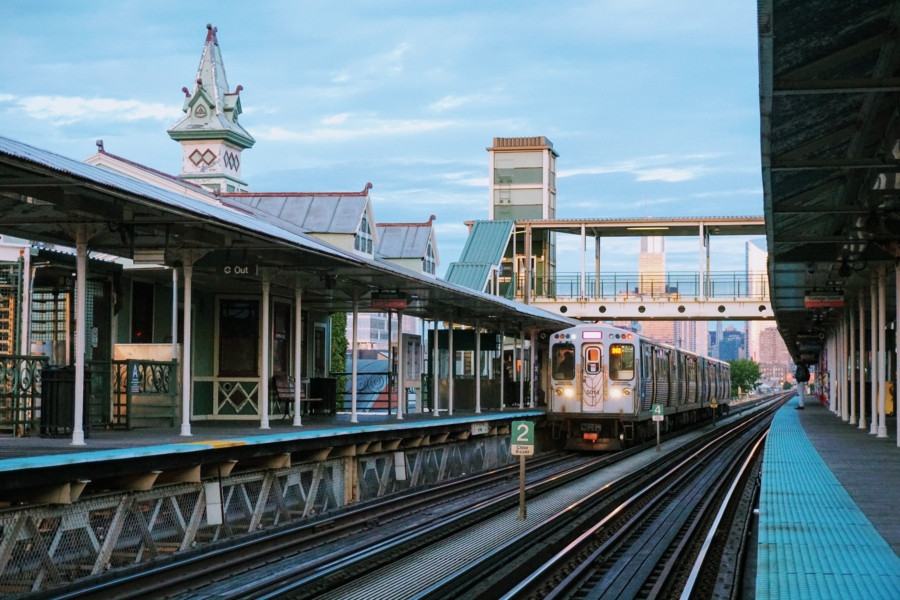 CTA train in Chicago
The Chicago Transit Authority (CTA) operates the nation’s second-largest public transportation system, making it a cornerstone of Chicago city transportation. The CTA encompasses the ‘L’ train system, with eight lines, and a comprehensive bus network with 129 routes.
Navigating the ‘L’ Train
The ‘L’ train, though not entirely elevated as the name might suggest, is a rapid transit system that efficiently connects various parts of the city via elevated tracks, street-level rails, and subway tunnels. Serving 145 stations throughout Chicago, the ‘L’ provides access to key destinations. Notably, the Blue Line (connecting O’Hare Airport to downtown) and the Red Line (North and South Sides via downtown) offer 24/7 service, ensuring transportation at any hour. Utilizing the ‘L’ train is a cost-effective and rapid way to travel across Chicago.
Utilizing CTA Buses
CTA buses provide extensive coverage across the city, with frequent stops located every few blocks. This expansive bus network complements the ‘L’ system, reaching areas not directly served by trains. Several bus routes offer “Night Owl” service, extending operations well past midnight, often until 2 a.m. or later. Buses are a convenient option for shorter distances and navigating specific neighborhoods.
Ventra Card and Mobile App
For seamless travel on both ‘L’ trains and buses, the Ventra system is essential. You can pay for single bus rides with cash, but purchasing a reloadable Ventra card or an Unlimited Ride Pass is recommended for frequent use. The Ventra app enhances convenience by allowing users to track real-time arrival and departure times for both buses and trains. Additionally, the app enables on-the-go balance reloading, making public transit payment hassle-free. For detailed information on fares, card retailers, maps, schedules, and real-time train trackers, the official CTA website is an invaluable resource.
Metra Commuter Rail: Connecting Suburbs to Downtown
For travel between downtown Chicago and the surrounding suburbs, Metra commuter rail is an efficient high-speed option. Metra provides a direct and rapid link to the city center from outlying areas. Tickets can be conveniently purchased via the Ventra app before boarding. First-time Metra riders can benefit from the New Riders Guide available on the Metra website, offering helpful tips and system overviews. Metra is ideal for commuters and visitors staying outside of downtown Chicago but wanting easy access to the city’s core.
Taxis: Readily Available Citywide
Taxis are a readily available mode of Chicago city transportation. They can be hailed on the street or conveniently e-hailed and paid for using CHICABS-approved apps like ARRO and CURB. All taxis in Chicago accept credit card payments, providing payment flexibility. Taxis offer a direct and private transportation option, particularly useful for point-to-point travel and navigating areas less accessible by public transit.
Ridesharing Services: Lyft and Uber
Ridesharing services like Lyft and Uber are immensely popular and easily accessible in Chicago. By downloading the respective apps, you can request on-demand rides throughout the city. Simply input your pickup location and destination to view fare options and request a ride. Ridesharing provides a convenient and often cost-effective alternative to taxis, especially during peak hours or in areas with high demand.
Water Taxis: Scenic River Transportation
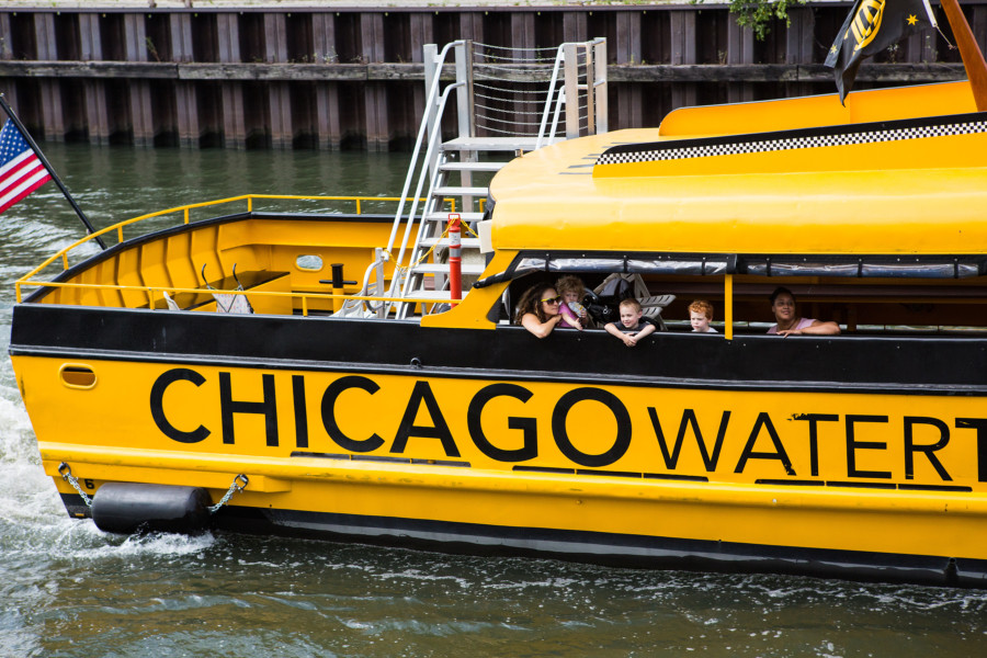 Chicago Water Taxi on the river
For a unique and scenic transportation experience, consider Chicago Water Taxi by Wendella Boats and Shoreline Water Taxi by Shoreline Sightseeing. These water taxis offer fast and enjoyable routes connecting major tourist destinations along the Chicago River. Destinations include Chinatown, Museum Campus, Willis Tower, Michigan Avenue, Union Station, and Navy Pier. Water taxis combine sightseeing with transportation, providing a refreshing perspective of the city from its waterways. Route maps and fare information are available on the respective water taxi service websites.
Shuttles and Car Services: Group and Premium Travel
For larger groups or those seeking premium transportation, Chicago offers various shuttle, car, and limousine services. These services are ideal for airport transfers, corporate events, or simply traveling in style. A comprehensive list of providers can be found on the Choose Chicago website, catering to diverse transportation needs.
Divvy Bike Sharing: Explore Chicago on Two Wheels
 Couple riding Divvy bikes along Chicago lakeshore
Chicago is a bike-friendly city with an extensive network of over 200 miles of bike lanes. Divvy, Chicago’s bike-sharing program, provides a fantastic way to explore the city on two wheels. With over 580 stations and 5,800 bikes citywide, Divvy offers 24/7 accessibility. Users can easily rent a bike from a docking station and return it to any station near their destination. The Divvy app helps locate stations and provides rate information. Cycling is a healthy, eco-friendly, and enjoyable way to experience Chicago’s sights and neighborhoods.
Parking in Downtown Chicago: Resources and Tips
Driving in downtown Chicago requires awareness of parking options and regulations. Resources are available to assist drivers, including information on road rules and real-time traffic conditions from the Illinois Department of Transportation. Planning ahead for parking and being mindful of city driving regulations is recommended when choosing to drive in downtown Chicago.
Conclusion
Chicago city transportation offers a diverse and efficient network catering to every need and preference. From the extensive CTA public transit system and walkable neighborhoods to taxis, rideshares, water taxis, and bike sharing, navigating Chicago is convenient and accessible. By understanding the available options and utilizing resources like the Ventra app and online guides, you can seamlessly explore all that this dynamic city has to offer.