San Diego offers a comprehensive public transportation network, making it easy to explore the city and surrounding areas. Whether you’re arriving at San Diego International Airport, commuting to work, or discovering attractions, understanding the public transportation map is key to efficient travel. This guide will walk you through the various options and how to utilize the San Diego Public Transportation Map for seamless journeys.
Understanding San Diego’s Public Transportation System and Maps
Navigating a new city’s public transportation can feel daunting, but San Diego’s system is well-organized and user-friendly, especially with the help of a comprehensive map. The Metropolitan Transit System (MTS) is the primary operator, providing bus and trolley services throughout the region. Additionally, the North County Transit District (NCTD) offers the COASTER commuter train and other bus services, extending your reach beyond downtown San Diego. A public transportation map is your essential tool for planning routes, understanding connections, and making the most of these services.
Key Public Transportation Services in San Diego
- MTS Bus: A vast network of bus routes covers much of San Diego, including direct service from the airport via Route 992. These buses are wheelchair accessible and connect to trolley and train lines.
- MTS Trolley: San Diego’s light rail system, the Trolley, features three lines (Blue, Orange, and Green) serving key destinations like downtown, Old Town, and the border.
- COASTER Train: The COASTER commuter train runs along the coast, connecting downtown San Diego (Santa Fe Depot) with North County cities like Oceanside, Carlsbad, and Encinitas, and further north to areas like Orange County and Los Angeles via Amtrak connections.
- San Diego Flyer: A free electric shuttle service dedicated to airport connections, running between San Diego International Airport and the Old Town Transit Center, linking to trolley, COASTER, and bus services.
- Amtrak: Amtrak’s Pacific Surfliner trains also serve San Diego’s Santa Fe Depot, providing intercity rail connections up the California coast and beyond.
Accessing the San Diego Public Transportation Map
Finding the San Diego public transportation map is straightforward. The primary sources are online, ensuring you always have the most up-to-date information.
- MTS Website: The Metropolitan Transit System (www.sdmts.com) is your central hub for bus and trolley maps. Their website offers interactive maps, downloadable PDFs, and trip planning tools. You can find detailed route maps for individual bus lines and comprehensive trolley system maps.
- NCTD Website: For COASTER, SPRINTER, and North County bus information, visit the North County Transit District (www.gonctd.com) website. Here, you’ll find COASTER line maps, regional transit maps encompassing NCTD services, and information on connections with MTS.
- Mobile Apps: Both MTS and NCTD offer mobile apps (e.g., PRONTO for NCTD) that often include interactive maps, real-time information, and trip planning features. These apps are invaluable tools for navigating on the go.
- Transit Centers and Stations: Major transit centers like the Old Town Transit Center and stations such as Santa Fe Depot usually have printed maps available for passengers.
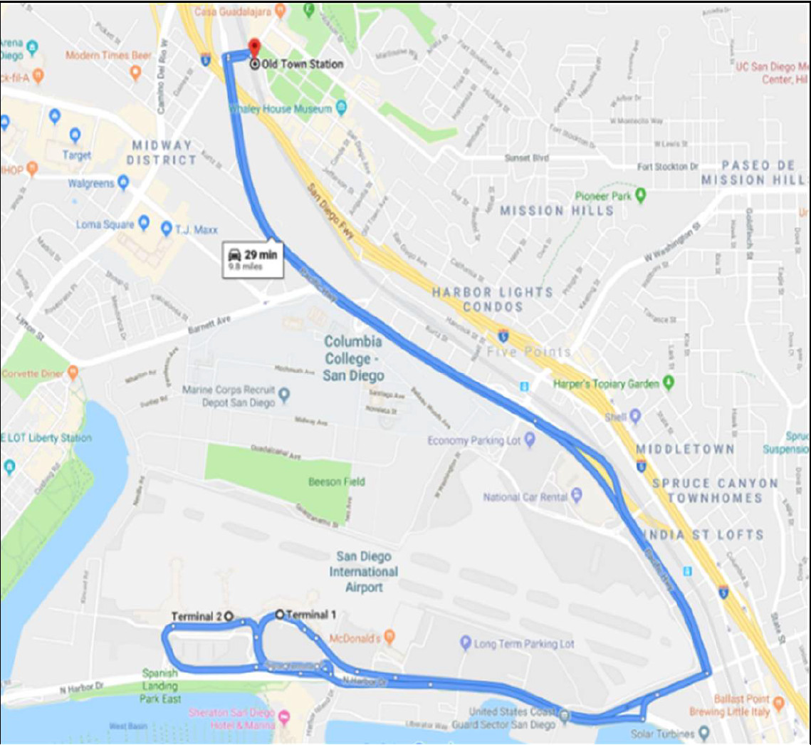
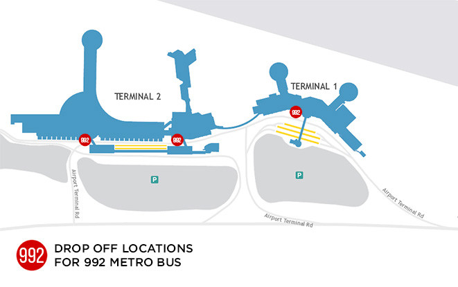 MTS 992 Bus Route connecting San Diego Airport to Downtown and Transit Connections
Utilizing the Public Transportation Map for Trip Planning
A San Diego public transportation map isn’t just a static image; it’s a dynamic tool for planning your journeys. Here’s how to effectively use it:
- Identify Your Starting Point and Destination: Locate your origin and destination on the map.
- Determine Available Routes: Examine the trolley lines and bus routes that serve your locations. Pay attention to transfer points if a direct route isn’t available.
- Check Schedules and Frequency: Once you’ve identified potential routes, consult the corresponding schedules (available on the MTS and NCTD websites or apps) to check operating times and service frequency. Route 992, for example, operates frequently between the airport and downtown.
- Look for Connections: The map will show connections between different modes of transport, such as bus-to-trolley or COASTER-to-bus transfers at transit centers like Old Town or Santa Fe Depot.
- Consider Real-Time Information: Many digital maps and apps offer real-time information on vehicle locations and potential delays, allowing for adjustments to your plan as needed.
For instance, travelers arriving at San Diego International Airport and heading downtown can easily find Route 992 on the MTS bus map. The map also clearly indicates that Route 992 connects with Trolley lines and the COASTER at Santa Fe Depot.
 San Diego Flyer Shuttle connecting Airport and Old Town Transit Center
Key Transportation Hubs and Map Resources
- Santa Fe Depot: Downtown San Diego’s historic train station, serving Amtrak and COASTER. It’s a major transfer point, connected to the Trolley Green Line and various bus routes. Maps of the station and surrounding transit options are available at the station and on the MTS website.
- Old Town Transit Center: A crucial hub connecting the Trolley Green Line, COASTER, San Diego Flyer shuttle, and numerous bus routes. This center is well-mapped, and resources are available online and on-site. Downloadable maps of the Old Town Transit Center are readily accessible.
- Airport Transportation Islands: While not a transit hub in itself, the transportation islands at Terminals 1 and 2 of San Diego International Airport are key pick-up/drop-off points for Route 992 and the San Diego Flyer. Signage and online resources act as a map for navigating airport connections.
 Map Icon for Old Town Transit Center Resources
Conclusion
Navigating San Diego’s public transportation becomes significantly easier with the aid of a public transportation map. By understanding the services available, knowing where to find maps (especially online via MTS and NCTD), and learning how to use them for trip planning, you can confidently explore San Diego and its surroundings. Whether you’re a visitor or a resident, utilizing these map resources will enhance your travel experience and allow you to take full advantage of San Diego’s efficient public transit network. For the most detailed and up-to-date maps, always refer to the official MTS (www.sdmts.com) and NCTD (www.gonctd.com) websites.