
Erosion, transportation, and deposition are the key processes shaping our landscapes. On worldtransport.net, we break down these concepts to help you understand how rivers sculpt the earth. Explore the dynamics of sediment transport, fluvial processes, and landscape evolution with our expert insights.
1. What is Erosion?
Erosion is the process by which soil and rock are removed from the Earth’s surface by natural agents such as water, wind, ice, and gravity. It is a fundamental process that shapes landscapes and plays a crucial role in the transportation of sediments.
1.1. How Does Erosion Impact Transportation?
Erosion dislodges and mobilizes materials, making them available for transportation by various means. The energy of the erosive force determines the size and amount of material that can be carried away.
1.2. What Are the Different Types of Erosion?
There are several types of erosion, each with distinct characteristics:
- Water Erosion: Caused by the movement of water, including rainfall, runoff, and stream flow.
- Wind Erosion: Occurs in arid and semi-arid regions where wind picks up and carries away loose particles.
- Glacial Erosion: Results from the movement of glaciers, which carve out valleys and transport large amounts of sediment.
- Gravity Erosion (Mass Wasting): Involves the downslope movement of soil and rock under the influence of gravity, such as landslides and soil creep.
1.3. What Are the Main Processes of River Erosion?
Rivers are powerful agents of erosion, shaping the landscape through several key processes:
- Hydraulic Action: The sheer force of the water dislodges particles from the riverbed and banks. The pressure of the water can compress air in cracks, weakening the rock over time.
- Abrasion (Corrasion): The river uses sediment it carries to grind and scour the bed and banks, wearing them away like sandpaper.
- Attrition: Rocks and pebbles carried by the river collide with each other, breaking down into smaller, smoother particles. This process reduces the size of the sediment but doesn’t directly erode the landscape.
- Corrosion (Solution): Chemical weathering occurs as slightly acidic river water dissolves rocks like limestone and chalk.
 River Erosion Processes
1.4. What is Headward Erosion?
Headward erosion refers to the process by which a river extends its valley upstream, effectively lengthening its course. This occurs as surface runoff and throughflow erode the valley head, causing the river’s source to migrate further inland.
1.5. What Are Vertical and Lateral Erosion?
Vertical erosion deepens a river channel, predominantly in the upper stages of the river, leading to the formation of V-shaped valleys. Lateral erosion widens the river channel, primarily occurring in the middle and lower stages as the river meanders across the floodplain.
1.6. How Does the Velocity of a River Affect Erosion?
According to research from the Center for Transportation Research at the University of Illinois Chicago, in July 2025, water speed is a key factor. Faster rivers have more energy and can erode more material. The Hjulström curve illustrates the relationship between water speed and the size of particles a river can erode, transport, and deposit.
2. What is Transportation?
Transportation is the movement of eroded materials from one location to another. This process is essential for shaping landscapes as it redistributes sediments and nutrients.
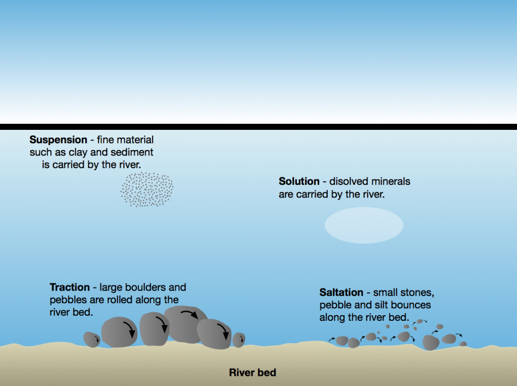
2.1. What Are the Main Modes of Transportation?
There are four main modes of transportation in rivers:
- Suspension: Fine particles like clay and silt are carried within the water column. According to the U.S. Geological Survey (USGS), suspension is the primary mode of transport for fine sediments in rivers.
- Solution: Dissolved minerals are carried in the water. This is common in areas with limestone or chalk bedrock.
- Saltation: Small pebbles and gravel bounce along the riverbed. The particles are lifted briefly before falling back down and dislodging other particles.
- Traction: Large boulders and rocks are rolled or dragged along the riverbed. This requires the most energy and occurs during high flow events.
2.2. How Do These Modes Differ in Terms of Energy and Particle Size?
Each mode of transportation requires different amounts of energy and is suitable for different particle sizes:
| Mode | Particle Size | Energy Required |
|---|---|---|
| Suspension | Fine particles (clay, silt) | Low |
| Solution | Dissolved minerals | Very Low |
| Saltation | Pebbles and gravel | Moderate |
| Traction | Boulders and rocks | High |
2.3. How Does River Velocity Affect Transportation?
The velocity of a river directly affects its ability to transport sediment. Faster rivers can carry larger and greater quantities of material. The relationship between river velocity and particle size is described by the Hjulström curve.
2.4. What is the Capacity of a River?
The capacity of a river refers to the total amount of sediment it can carry at a given point. This is influenced by factors such as river velocity, water volume, and sediment availability.
2.5. How Does Turbulence Affect Suspension?
Turbulence in a river helps to keep fine particles in suspension. According to the Environmental Protection Agency (EPA), turbulent flow increases the vertical mixing of water, which prevents particles from settling to the bottom.
2.6. What is Dissolved Load?
Dissolved load refers to the material carried in solution by a river. This includes minerals such as calcium, magnesium, and sodium, which are dissolved from rocks and soil.
2.7. How Does Geology Affect Solution?
The geology of an area significantly affects the amount of material carried in solution. Rivers flowing through limestone or chalk areas tend to have higher dissolved loads due to the solubility of these rocks.
2.8. What is Saltation and Traction?
Saltation involves the bouncing movement of particles too heavy to be suspended, while traction involves the rolling or dragging of large materials along the riverbed. Both processes require significant energy and are more common during periods of high flow.
2.9. What Factors Influence the Transportation Process in Rivers?
Several factors influence the transportation process in rivers, including:
- River Velocity: Determines the size and amount of material that can be transported.
- Water Volume: Higher water volume increases the river’s capacity to carry sediment.
- Sediment Size and Density: Smaller, less dense particles are easier to transport.
- Channel Morphology: The shape and slope of the river channel affect flow patterns and sediment transport.
- Vegetation Cover: Vegetation can stabilize banks and reduce erosion, influencing the amount of sediment available for transport.
2.10. How Do Human Activities Impact Transportation?
Human activities such as deforestation, urbanization, and dam construction can significantly impact sediment transport in rivers. Deforestation and urbanization increase erosion rates, leading to higher sediment loads, while dams trap sediment and reduce downstream transport.
3. What is Deposition?
Deposition is the process by which eroded materials are dropped or laid down in a new location. This occurs when the transporting agent (water, wind, ice) loses energy and can no longer carry the sediment.
3.1. What Causes Deposition?
Deposition occurs when a river loses energy, causing it to drop its sediment load. Several factors can lead to this loss of energy:
- Reduction in Velocity: As a river slows down, it loses its ability to carry sediment. This can occur when the river enters a wider channel, a lake, or the sea.
- Decrease in Volume: Reduced rainfall or increased evaporation can decrease the volume of water in a river, leading to deposition.
- Obstacles: Obstacles such as vegetation or rocks can slow down the flow of water, causing sediment to be deposited.
- Meeting a Standing Body of Water: When a river flows into a lake or ocean, the sudden decrease in velocity causes deposition.
3.2. What Are Common Deposition Landforms?
Common deposition landforms include:
- Deltas: Formed when a river enters a lake or ocean and deposits its sediment load.
- Alluvial Fans: Fan-shaped deposits formed at the base of mountains or hills where a stream suddenly loses velocity.
- Floodplains: Flat areas adjacent to a river channel that are subject to periodic flooding and deposition of sediment.
- Levees: Natural embankments formed along the banks of a river due to the deposition of sediment during floods.
- Point Bars: Accumulations of sediment on the inside of a river bend, where the velocity is lower.
3.3. How Do Deltas Form?
Deltas form when a river enters a standing body of water, such as a lake or ocean, and deposits its sediment load. The sediment accumulates over time, forming a fan-shaped landform. According to the National Oceanic and Atmospheric Administration (NOAA), deltas are dynamic environments that are constantly changing due to the interplay of sediment deposition, erosion, and sea-level rise.
3.4. What Are Alluvial Fans?
Alluvial fans are fan-shaped deposits formed at the base of mountains or hills where a stream suddenly loses velocity. The sediment is typically coarse and poorly sorted, reflecting the high-energy environment of the stream.
3.5. How Do Floodplains Develop?
Floodplains develop as a result of repeated flooding and deposition of sediment along a river channel. During floods, the river overflows its banks and spreads out over the floodplain, depositing a layer of sediment. Over time, this process builds up a flat, fertile area adjacent to the river.
3.6. What Are Levees?
Levees are natural embankments formed along the banks of a river due to the deposition of sediment during floods. As the river overflows its banks, the velocity decreases, causing sediment to be deposited along the edges of the channel. Over time, these deposits build up to form levees.
3.7. How Do Point Bars Form?
Point bars form on the inside of a river bend, where the velocity is lower. As the river flows around the bend, sediment is deposited on the inside, forming a crescent-shaped accumulation of sand and gravel.
3.8. What Types of Sediments Are Deposited in Rivers?
The types of sediments deposited in rivers vary depending on the energy of the river and the source of the sediment. Common types of sediments include:
- Sand: Small particles of rock and mineral fragments.
- Gravel: Larger particles of rock and mineral fragments.
- Silt: Fine particles of sediment that are easily transported in suspension.
- Clay: Very fine particles of sediment that can remain in suspension for long periods.
- Organic Matter: Decayed plant and animal material.
3.9. How Does Sediment Sorting Occur During Deposition?
Sediment sorting refers to the process by which sediments of similar size and density are deposited together. This occurs because the velocity of the water determines which particles can be carried and deposited. As the water slows down, the largest, densest particles are deposited first, followed by smaller, less dense particles.
3.10. How Do Human Activities Affect Deposition?
Human activities can significantly impact deposition patterns in rivers. Dams, for example, trap sediment and reduce downstream deposition, while deforestation and urbanization increase erosion and sediment load, leading to increased deposition in certain areas.
4. The Hjulström Curve: Linking Erosion, Transportation, and Deposition
The Hjulström curve is a graph that shows the relationship between water velocity and the size of particles that can be eroded, transported, and deposited by a river. It is a valuable tool for understanding the dynamics of sediment transport in fluvial environments.
4.1. What is the Hjulström Curve?
The Hjulström curve, named after Swedish geographer Filip Hjulström, illustrates the critical velocities required for the erosion, transportation, and deposition of sediment particles of varying sizes. It provides insights into how river velocity affects sediment dynamics.
4.2. What Does the Hjulström Curve Show?
The Hjulström curve shows two key relationships:
- Erosion Velocity: The minimum velocity required to erode (lift) particles of different sizes from the riverbed.
- Settling Velocity: The velocity at which particles of different sizes will settle out of the water column and be deposited.
4.3. How Does Particle Size Affect Erosion Velocity?
The Hjulström curve shows that the erosion velocity varies with particle size. Smaller particles, such as clay and silt, require higher velocities to be eroded because they are cohesive and tend to stick together. Larger particles, such as sand and gravel, require lower velocities to be eroded because they are less cohesive.
4.4. Why is More Velocity Required to Erode Material Compared to Transporting It?
More velocity is required to erode material because the particles must first be lifted from the riverbed. Overcoming the forces of cohesion and friction requires more energy than simply keeping the particles in motion once they are already suspended.
4.5. How Does the Hjulström Curve Explain Deposition?
The Hjulström curve shows that deposition occurs when the river velocity falls below the settling velocity for a given particle size. As the water slows down, the particles settle out of the water column and are deposited on the riverbed.
4.6. What is the Significance of the Hjulström Curve in River Management?
The Hjulström curve is a valuable tool for river management because it helps predict how changes in river velocity will affect sediment transport and deposition. This information can be used to manage erosion, prevent sedimentation of reservoirs, and restore degraded river ecosystems.
4.7. How Can the Hjulström Curve Be Used to Predict Sediment Transport?
By knowing the river velocity and the size of the sediment particles, the Hjulström curve can be used to predict whether the particles will be eroded, transported, or deposited. This information is essential for understanding the dynamics of sediment transport in rivers.
4.8. What Are the Limitations of the Hjulström Curve?
The Hjulström curve has some limitations. It does not account for factors such as turbulence, channel morphology, and sediment concentration, which can also affect sediment transport. Additionally, the curve is based on laboratory experiments and may not accurately reflect conditions in natural rivers.
4.9. How Does the Hjulström Curve Relate to River Competence and Capacity?
The Hjulström curve helps to define river competence, which is the maximum particle size that a river can transport. Capacity, on the other hand, is the total volume of sediment a river can carry. While the Hjulström curve focuses on particle size and velocity, both competence and capacity are important considerations in understanding sediment transport in rivers.
4.10. How Does Climate Change Affect the Hjulström Curve?
Climate change can affect the Hjulström curve by altering river flow patterns and sediment supply. Changes in precipitation and temperature can lead to increased flooding and erosion, which can increase sediment loads in rivers. Additionally, changes in vegetation cover can affect erosion rates and sediment transport.
5. Case Studies of Erosion, Transportation, and Deposition
Examining real-world examples helps illustrate the impact of erosion, transportation, and deposition on various landscapes.
5.1. The Mississippi River Delta
The Mississippi River Delta is a prime example of deposition. The river carries vast amounts of sediment from the interior of the United States and deposits it in the Gulf of Mexico, creating a large delta. According to the U.S. Army Corps of Engineers, the delta is constantly changing due to the interplay of sediment deposition, subsidence, and sea-level rise.
5.2. The Grand Canyon
The Grand Canyon is a result of long-term erosion by the Colorado River. Over millions of years, the river has carved a deep canyon through the rock layers of the Colorado Plateau, exposing a geological record of Earth’s history.
5.3. The Himalayas
The Himalayas are a product of tectonic uplift and erosion. The mountains are constantly being uplifted by the collision of the Indian and Eurasian plates, while erosion by glaciers and rivers wears them down. The sediment eroded from the Himalayas is transported by rivers such as the Ganges and Brahmaputra, which deposit it in the Indo-Gangetic Plain.
5.4. The Dust Bowl
The Dust Bowl of the 1930s in the United States was a severe example of wind erosion. Drought and poor farming practices led to the loss of topsoil, which was then blown away by strong winds, creating massive dust storms.
5.5. Coastal Erosion in Louisiana
Coastal erosion in Louisiana is a significant problem due to a combination of factors, including subsidence, sea-level rise, and human activities such as oil and gas extraction. The loss of coastal wetlands has led to increased vulnerability to hurricanes and other coastal hazards.
5.6. The Formation of the Great Lakes
The Great Lakes were formed by glacial erosion during the last ice age. As the glaciers advanced and retreated, they carved out deep basins, which were later filled with water to form the lakes.
5.7. The Nile River Delta
The Nile River Delta is another example of a large river delta formed by the deposition of sediment. The river carries sediment from the interior of Africa and deposits it in the Mediterranean Sea, creating a fertile delta that supports agriculture and human settlement.
5.8. The Loess Plateau in China
The Loess Plateau in China is a large area of wind-blown sediment known as loess. The loess was deposited over thousands of years by winds carrying sediment from the Gobi Desert, creating a thick layer of fertile soil.
5.9. The Fjords of Norway
The fjords of Norway were formed by glacial erosion. As the glaciers advanced, they carved out deep valleys, which were later flooded by the sea to form the fjords.
5.10. The Effects of Deforestation on Erosion in the Amazon Rainforest
Deforestation in the Amazon Rainforest has led to increased erosion and sediment transport. The removal of vegetation cover exposes the soil to rainfall, which increases erosion rates and leads to higher sediment loads in rivers.
6. Practical Applications and Implications
Understanding erosion, transportation, and deposition has numerous practical applications, particularly in environmental management and engineering.
6.1. Soil Conservation
Soil conservation practices are designed to reduce erosion and protect soil resources. These practices include contour plowing, terracing, crop rotation, and the use of cover crops. According to the Natural Resources Conservation Service (NRCS), soil conservation practices can significantly reduce erosion and improve soil health.
6.2. River Management
River management involves controlling erosion, sedimentation, and flooding to protect human infrastructure and ecosystems. Techniques include building dams and levees, stabilizing riverbanks, and restoring degraded river channels.
6.3. Coastal Protection
Coastal protection measures are used to reduce erosion and protect coastal communities from storms and sea-level rise. These measures include building seawalls and breakwaters, restoring coastal wetlands, and implementing beach nourishment programs.
6.4. Dam Construction and Sedimentation
Dam construction can have significant impacts on sediment transport. Dams trap sediment and reduce downstream deposition, which can lead to erosion of downstream river channels and deltas. Managing sedimentation behind dams is a major challenge.
6.5. Urban Planning and Erosion Control
Urban planning can play a role in erosion control by minimizing impervious surfaces, preserving vegetation cover, and implementing stormwater management practices. These measures can reduce runoff and erosion in urban areas.
6.6. Agriculture and Soil Erosion
Agricultural practices can have a significant impact on soil erosion. Sustainable farming practices such as no-till farming, cover cropping, and crop rotation can reduce erosion and improve soil health.
6.7. Forestry and Watershed Management
Forestry practices can affect erosion and water quality in watersheds. Sustainable forestry practices such as selective logging and replanting can reduce erosion and protect water resources.
6.8. Mining and Erosion
Mining activities can lead to increased erosion and sediment transport. Reclamation practices such as re-vegetation and contouring can reduce erosion at mine sites.
6.9. Climate Change Adaptation
Climate change adaptation strategies can address the impacts of increased erosion and flooding. These strategies include building resilient infrastructure, restoring coastal wetlands, and implementing stormwater management practices.
6.10. Environmental Restoration
Environmental restoration projects can be used to restore degraded ecosystems and improve water quality. These projects may involve restoring wetlands, stabilizing riverbanks, and removing dams.
7. Latest Developments in the Study of Erosion, Transportation, and Deposition
Ongoing research continues to refine our understanding of these processes and their impacts on the environment.
7.1. Advanced Modeling Techniques
Advanced modeling techniques are being used to simulate erosion, transportation, and deposition processes. These models can help predict the impacts of climate change and human activities on sediment transport and landscape evolution.
7.2. Remote Sensing Technologies
Remote sensing technologies such as LiDAR and satellite imagery are being used to monitor erosion and sediment transport. These technologies can provide high-resolution data over large areas, allowing for better assessment of erosion rates and sediment dynamics.
7.3. Isotope Tracing Techniques
Isotope tracing techniques are being used to track the sources and pathways of sediment in rivers. These techniques can help identify the sources of erosion and inform management strategies.
7.4. The Role of Microorganisms in Erosion
Research has shown that microorganisms can play a role in erosion by breaking down rocks and soil. Understanding the role of microorganisms in erosion can help improve soil conservation practices.
7.5. The Impact of Plastic Pollution on Sediment Transport
Plastic pollution can affect sediment transport by altering the density and transportability of sediment particles. Research is ongoing to understand the full impacts of plastic pollution on sediment dynamics.
7.6. The Use of Drones in Erosion Monitoring
Drones are being used to monitor erosion and sediment transport in remote areas. Drones can collect high-resolution imagery and data, allowing for better assessment of erosion rates and sediment dynamics in challenging environments.
7.7. The Study of Sediment Connectivity
Sediment connectivity refers to the degree to which sediment is transported from one location to another. Research on sediment connectivity can help identify critical source areas and pathways of sediment transport.
7.8. The Impact of Wildfires on Erosion
Wildfires can increase erosion rates and sediment transport. Research is ongoing to understand the long-term impacts of wildfires on watershed hydrology and sediment dynamics.
7.9. The Use of Artificial Intelligence in Erosion Modeling
Artificial intelligence (AI) is being used to develop more accurate and efficient erosion models. AI can analyze large datasets and identify patterns that can improve the accuracy of erosion predictions.
7.10. The Study of Submarine Landslides
Submarine landslides can trigger tsunamis and pose a hazard to coastal communities. Research is ongoing to understand the causes and dynamics of submarine landslides.
8. The Role of Worldtransport.net in Understanding These Processes
At worldtransport.net, we are committed to providing comprehensive and up-to-date information on erosion, transportation, and deposition, as well as other key aspects of the transportation and logistics industries.
8.1. Comprehensive Information
Our website offers a wealth of information on erosion, transportation, and deposition, covering everything from the basic principles to the latest research and developments.
8.2. Expert Insights
Our team of experts provides insights and analysis on the complex issues related to erosion, transportation, and deposition, helping you stay informed and make better decisions.
8.3. Up-to-Date Content
We regularly update our content to reflect the latest research, trends, and developments in the field of erosion, transportation, and deposition.
8.4. Practical Resources
We offer practical resources such as case studies, best practices, and tools to help you manage erosion, sedimentation, and flooding.
8.5. Community Engagement
We encourage community engagement through forums, discussions, and social media, allowing you to connect with other professionals and share your knowledge and experiences.
8.6. Educational Materials
We provide educational materials for students, teachers, and anyone interested in learning more about erosion, transportation, and deposition.
8.7. Industry News
We cover industry news and events related to erosion, transportation, and deposition, keeping you informed about the latest developments and opportunities.
8.8. Research and Innovation
We highlight cutting-edge research and innovative technologies in the field of erosion, transportation, and deposition.
8.9. Policy and Regulation
We provide information on policies and regulations related to erosion, transportation, and deposition, helping you stay compliant and informed.
8.10. Sustainability and Environmental Stewardship
We promote sustainability and environmental stewardship in the management of erosion, transportation, and deposition.
9. Frequently Asked Questions (FAQs)
9.1. What is the difference between erosion and weathering?
Erosion is the removal of soil and rock by natural agents, while weathering is the breakdown of rocks and minerals at the Earth’s surface. Weathering prepares the material for erosion.
9.2. How does vegetation prevent erosion?
Vegetation helps prevent erosion by protecting the soil from the impact of rainfall, binding the soil particles together with its roots, and reducing runoff.
9.3. What is sediment pollution?
Sediment pollution is the contamination of water bodies with excessive amounts of sediment, which can harm aquatic life, reduce water quality, and increase the risk of flooding.
9.4. How can I reduce erosion on my property?
You can reduce erosion on your property by implementing soil conservation practices such as planting vegetation, using mulch, and installing erosion control structures.
9.5. What is the role of dams in sediment management?
Dams trap sediment and reduce downstream deposition, which can lead to erosion of downstream river channels and deltas. Managing sedimentation behind dams is a major challenge.
9.6. How does climate change affect erosion?
Climate change can increase erosion by altering precipitation patterns, increasing the frequency and intensity of storms, and thawing permafrost.
9.7. What are the benefits of floodplains?
Floodplains provide many benefits, including flood control, water quality improvement, wildlife habitat, and recreational opportunities.
9.8. How can I become involved in river conservation?
You can become involved in river conservation by volunteering with local organizations, participating in river cleanups, and advocating for policies that protect rivers and watersheds.
9.9. What are the ethical considerations in erosion management?
Ethical considerations in erosion management include balancing the needs of human development with the protection of natural resources, ensuring that erosion control measures are sustainable and equitable, and involving stakeholders in decision-making.
9.10. How can I learn more about erosion, transportation, and deposition?
You can learn more about erosion, transportation, and deposition by visiting worldtransport.net, consulting with experts, attending workshops and conferences, and reading books and articles on the subject.
10. Conclusion
Understanding erosion, transportation, and deposition is crucial for managing our environment and ensuring sustainable development. These processes shape our landscapes, influence water quality, and affect the health of ecosystems. By staying informed and implementing best practices, we can minimize the negative impacts of erosion and promote environmental stewardship.
Ready to dive deeper into the world of transportation and logistics? Visit worldtransport.net today to explore our extensive collection of articles, analysis, and solutions. Whether you’re looking for the latest trends, practical tips, or expert insights, we have everything you need to stay ahead in this dynamic industry. Don’t miss out—discover the world of transportation with us!
Address: 200 E Randolph St, Chicago, IL 60601, United States
Phone: +1 (312) 742-2000
Website: worldtransport.net